


Méaudre - Autrans

maupassant38
User
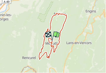

Length
36 km

Max alt
1415 m

Uphill gradient
848 m
Km-Effort
47 km

Min alt
956 m

Downhill gradient
850 m
Boucle
Yes
Creation date :
2021-06-11 08:44:25.581
Updated on :
2021-06-11 11:43:08.327
2h04
Difficulty : Medium

FREE GPS app for hiking
 SityTrail
IGN / Geographical institutes
SityTrail Plus
The world is yours!
About
Trail Mountain bike of 36 km to be discovered at Auvergne-Rhône-Alpes, Isère, Autrans-Méaudre en Vercors. This trail is proposed by maupassant38.
Positioning
Country:
France
Region :
Auvergne-Rhône-Alpes
Department/Province :
Isère
Municipality :
Autrans-Méaudre en Vercors
Location:
Méaudre
Start:(Dec)
Start:(UTM)
698749 ; 5000572 (31T) N.
Comments